The content of this page needs an update version of your flash player :

Digital modelling in 3 dimensions

Further to the on-site completion of 3D laser scans, Urbica will retrieve and process hundreds of millions of measurements.
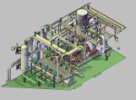
Urbica uses dedicated software tools for the 3D modelling of surveyed objects in accordance with their actual condition. Each structure, device or facility is reconstituted in graphic form for restitution in conventional CAD tools.
Shape recognition on the basis of the cloud of points will provide the user with a 3D model or "3D pattern" which is true to life, accurate and exhaustive.
This modelling process may be completed on the basis of standardized ISO or AFNOR catalogues. In general, however, it will be more cost-effective to work on a volumetric or primitive model, as the existing site, in many cases, will no longer correspond to the notional models included in catalogues.
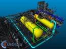
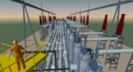
Upon the completion of modelling, Urbica will deliver a file of the 3D-scanned site or installation which will allow the following :
- the recording of distances between equipment;
- a virtual tour of the installation concerned;
- the identification of pipe diameters or the shape of supports;
- the generation of isometrics, plan views or layouts;
- the display or concealment of different layers, according to the "functional application" concerned (structure, piping, instrumentation, equipment, etc.);
- the detection, analysis, documentation and resolution of collisions between a 3D project and the 3D as-built model;
- the delivery of an up-to-date 3D model for the execution of maintenance, redevelopment or expansion analyses.