The content of this page needs an update version of your flash player :

Digitized files in 2 dimensions

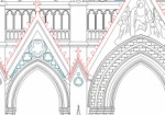
The digitization of "two-dimensional" plans has been a core business of Urbica from its earliest days. With the advent of technologies such as 3D laser scanning, there is now a new way to produce plans, plan views, elevations, section views or profiles. 2D views can be extracted from a 3D point cloud in any direction, and in any position required. Accordingly, once a survey is complete, there is no need to return to the site: all the raw material you need is right there in your office and in your software, just as it exists in the field. All you have to do is select the number, the “pitch” and the direction of views. In many cases, 2D sections extracted from a point cloud will be more accurate than a 3D model. These sections are entirely faithful to the outlines of the digitized entity. As well as being more cost-effective than a 3D model, a 2D plan provides a clear version of an installation for a user who is not versed in 3D CAD softwares. A section or profile generated from a 3D scanner survey can take one of two forms:
- in “point cloud” form, it will comprise a single extraction of the desired view from the overall file,
- in “vectorized” form, it will require a plotting phase by an operator.
2D files are often requested in addition to a ScanReview, point cloud or 3D model of the scanned installation. Amongst other applications, 2D files will allow the following:
- control of the conformity of construction plans with actual conditions,
- the updating of PIDs, isometrics, plot plans, layouts, profiles, plan views and sections,
- the delivery of plans which are compliant with regulatory requirements.
.jpg)