The content of this page needs an update version of your flash player :

End products :

The files delivered for your use are an integral element of the digital surveys which we conduct.
In this regard, the range of available services is constantly developing :
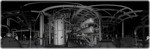
- Visualization of panoramic views and the direct exchange of geolocalized information on 3D shots generated by surveys;
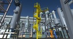
- Clouds of points with increasingly accurate resolution, suitable for applications of near-model quality;
- Total or partial modelling of a site or facility within competitive time schedules and at competitive hourly rates;
- Processing of surveys by the customary approach applied to conventional surveys, for the creation of plot plans, sections, profiles, etc.
- Extra high-definition 360° photos, which can be combined into panoramic views.