The content of this page needs an update version of your flash player :

Benefits of laser scanning for offshore oil operations
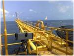
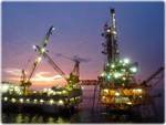
Works executed on an offshore platform, barge or vessel are, to say the least, singular; remote in the extreme, subject to stringent safety rules and conducted in obvious confinement, they can hardly be said to offer a congenial environment.
The facility to travel with a minimum of luggage, and to complete surveys whilst maintaining independence, speed, efficiency and mobility are critical attributes.
With its high-efficiency batteries, all-terrain computers, compact, high-performance scanners and a team well-versed in this type of operation, Urbica has the capability to rise to this kind of challenge.
APPLICATIONS
- Addition of new equipment to an existing site
- Kinematics for the movement of equipment in situ
- Conformity control of a new installation
- Control of structural deformation
- Creation of an equipment data base
- Generation of an "as-built" or "as-existing" base plan
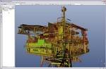
- Generation of a 3D model of an existing installation
- Dismantling
- Clash detection between as-built condition and plan or project
- Feasibility analysis, process, preliminary plans
- Generation of 3D (or 2D) plans of petrochemical sites
- Generation of a plot plan, layout, plan view or isometric, coupe
- Virtual 3D reconstruction for the simulation of a
maintenance or safety operation - Installation or replacement of equipment or skid
- Maintenance (piping, equipment, structure)
- Updating of equipment data base
- Updating of existing plans
- Dimensional analysis of a flare line
- Piping analysis for an existing system, tie-in
- Survey of piping systems
- Revamping of an existing installation
- Non-contact scanning, with no interruption of production
back to top of page
BENEFITS
- Generation of a 3D model of the existing structure in the required file format
souhaité (PDMS, PDS, Autocad, Microstation, 3DSM...) - Specialized team of topographers
- 3D or 2D data files, obtained by the same survey campaign
- On-site operations throughout the world
- Long-term experience in the oil sector
- Appropriate equipment, BOSIET-HUET qualified personnel
- High precision of scans
- Exhaustive scans
- Results suitable for processing in all CAD tools
- Rapid results, often available for processing within days of on-site scanning
- Tailored service
- Speed of capture of on-site measurements
back to top of page
END PRODUCTS
- Files types: Autocad (DXF/DWG), Microstation (DGN), Solidworks, 3DStudioMax (3ds & max),
3Dipsos (IPS), Realworks (RWP), Pointools (POD/PTL) , PDMS (macros), PDS
and of course all the open format files like IGES, OBJ, STEP, VRML etc... - 3D images, including comments and collaborative exchange (Scan-review)
- 3D model
- Structured 3D model, with attached catalog
- Points cloud
- 2 dimensional images (cut sections, layouts, …)
- 2 dimensional digitized file ( cut sections, layouts,…)
- Scan-review (Collaborative review of laser survey through panoramic images)
back to top of page
REFERENCES