The content of this page needs an update version of your flash player :

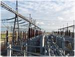
3D laser survey for energy production
In the decades ahead, energy will be the core industrial sector: demand will continue to rise, while resources will be increasingly fragile.
In the immediate future, the production of a kilowatt of electricity or a litre of oil will need to satisfy environmental requirements (regarding CO² emissions, flaring, radioactive wastes, etc.).
The upgrading of installations to meet standards will be a key economic factor for industrial operators and maintenance companies.
In this quest to hunt down “non-conformities” (and savings), Urbica can offer a range of tailored solutions which are essential to the early stages of analyses.
The initial applications are set out here – in the certainty that the future will lead to the discovery of others.

APPLICATIONS
- Addition of new equipment to an existing site
- Kinematics for the movement of equipment in situ
- Conformity control of a new installation
- Deformation control of civil engineering structures
- Generation of an "as-built" or "as-existing" base plan
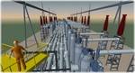
- Generation of a 3D model of a space, room or building
- Creation and updating of an equipment data base
- Displacement of a generator or turbine
- Clash detection between as-built condition and plan or project
- Feasibility analysis
- Generation of a plan view, section, elevation or isometric
- Management of industrial facilities
- Installation of new equipment on an existing site
- Maintenance (piping, equipment, structure)
- Updating of existing plans
- 3D Dimensional survey and measurements
- Pipe connection on an existing system (tie-in)
- Replacement or addition of a skid on site
- Revamping of an existing installation
- Virtual 3D inspection of installations
back to top of page
BENEFITS
- Generation of a 3D model of the existing structure in the required file format
(PDMS, PDS, Autocad, Microstation, 3DSMax, etc.) - Specialized team of topographers
- 3D or 2D data files, obtained by the same survey campaign
- On-site operations throughout the world
- Scans with a high precision and a high level of details
- Results suitable for processing in all CAD tools
- Rapid results, often available for processing within days of on-site scanning
- Tailored service
- H0B0-qualified personnel
- Non-contact measurement scanning
- Operations with no interruption of production
- Speed of capture of on-site measurements
back to top of page
END PRODUCTS
- Files types: Autocad (DXF/DWG), Microstation (DGN), Solidworks, 3DStudioMax (3ds & max),
3Dipsos (IPS), Realworks (RWP), Pointools (POD/PTL) , PDMS (macros), PDS
and of course all the open format files like IGES, OBJ, STEP, VRML etc... - Volumic 3D model
- Structured 3D model, with attached catalog
- Exhaustive high-density point cloud
- 2 dimensional images (cut sections, layouts, …)
- 2 dimensional digitized file ( cut sections, layouts,…)
- Scan-review (Collaborative review of laser survey through panoramic images)
back to top of page
REFERENCES