The content of this page needs an update version of your flash player :

Dimensional surveys for land-based oil sites
Land-based oil production sites are big. Very big.
From the refinery to the pipe rack, the distances involved run to hundreds of metres.
Notwithstanding this size, surveying requirements also encompass more confined zones of the installation, where higher accuracy is required.
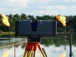
For this reason, Urbica has a scanner with a range of 300 metres, together with two more high-speed and accurate devices for measurements within a range of less than 40 metres.
In consequence, time spent on-site can be optimized - and time is more than just money.

APPLICATIONS
- Addition of new equipment to an existing site
- Kinematics for the movement of equipment in situ
- Conformity control of a new installation
- Control of structural deformation
- Creation of an equipment data base
- Generation of an "as-built" or "as-existing" base plan
- Generation of a 3D model of an existing installation
- Dismantling
- Clash detection between as-built condition and plan or project
- Feasibility analysis
- Generation of 3D (or 2D) plans of petrochemical sites
- Generation of a plot plan, layout, plan view or isometric, coupe
- Management of industrial facilities
- Installation of new equipment on an existing site
- Maintenance (piping, equipment, structure)
- Updating of equipment data base
- Updating of existing plans
- 3D Dimensional survey and measurements
- Piping connection on an existing system
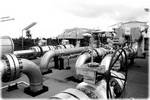
- Survey of pipe rack
- Survey of piping systems
- Replacement of equipment
- Replacement or addition of a skid on site
- 3D inspection of an installation
- Revamping of an existing installation
back to top of page
BENEFITS
- Generation of a PDMS/PDS model of the existing structure
- Specialized team of topographers
- 3D or 2D data files, obtained by the same survey campaign
- On-site operations throughout the world
- Long-term experience in the field pétrolier
- Matériel adapté
- High precision of scans
- Exhaustive scans
- Results suitable for processing in all CAD tools
- Rapid results, often available for processing within days of on-site scanning
- Tailored service
- Speed of capture of on-site measurements
- Non-contact scanning, with no interruption of production
back to top of page
END PRODUCTS
- Files types: Autocad (DXF/DWG), Microstation (DGN), Solidworks, 3DStudioMax (3ds & max),
3Dipsos (IPS), Realworks (RWP), Pointools (POD/PTL) , PDMS (macros), PDS
and of course all the open format files like IGES, OBJ, STEP, VRML etc... - 3D model
- Structured 3D model, with attached catalog
- High density point cloud, with a high level of detail
- 2 dimensional images (cut sections, layouts, …)
- 2 dimensional digitized file ( cut sections, layouts,…)
- Scan-review (Collaborative review of laser survey through panoramic images)
back to top of page
Types of installations operated
- Refineries
- Oil storage depots
- Pumping stations and manifolds
- Petrochemicals units
- Petroleum derivatives plants
back to top of page
REFERENCES